

After spending some 60 days in Bhutan and Nepal, I travelled overland to Tibet, China and made my way to the base camp of Mt Qomolangma (i.e. Mt Everest). I travelled over 2200km during my 11 days in Tibet including some 1500km along the Friendship Highway (National Highway 318) from Zhangmu in the Shigatse Prefecture in the southwest to Ranwuzhen in Bome County in the Nyinchi Prefecture in eastern Tibet. I have tried to visit the Namtso Lake 240 northwest of Lhasa twice without success. I am captivated by the stunning landscape and scenery.
China is the world’s second largest economy, the fourth largest country in term of area (over 9.5 million square kilometres) and the most populated with 1.3 billion people. It has 23 provinces, five autonomous regions, four municipalities (Beijing, Shanghai, Chongqing and Tianjin) and two special administrative regions (namely Hong Kong and Macau).
Tibet is one of the five Autonomous Regions in China. It has a total area of about 1.2 million square kilometres and a small population of 3 million. It has one prefecture-level city (i.e. Lhasa) and six prefectures. Over 90% of the population is of Tibetan origin. Located in the Qinghai-Tibet Plateau, the world’s highest plateau, Tibet’s average elevation is over 4000m. Mt Qomolangma, the world’s highest peak at 8848m is located at the Sino-Nepali border. Tibet is the ‘Roof of the World’ and has more than 50 peaks over 7000m.
With its spectacular landscape and scenery, rich wildlife and cultures, Tibet has been one of the dream destinations of world travellers. The newly completed (or rather upgraded) Beijing – Lhasa Railway has made this mystical region more accessible to visitors. I first visited Tibet and spent a few days in Lhasa and Shigatse in 1995 and have dreamed of a second visit ever since.
May 15: Kathmandu, Nepal – 0ld Tingri, China (over 300km; 8hrs)
Despite a strike in Nepal, Himalaya Trailfinder (the tour operator organised my two treks in Nepal) managed to find me a driver to take me to the border for US$80. I saw clashes between the crowd and the policemen in two towns. It’s frightening. The driver managed to take detours to avoid road blocks on several occasions. He also gave free lifts to some old people, women and children as there’s no bus service. I left Kathmandu about 10am and arrived at Kodari, the border town before 3pm. I saw many trucks parked along the road to Kodari. According to the driver, some have been waiting to load their trucks or for clearance for weeks. Life must be difficult for these drivers.
After crossing the Friendship Bridge, I was back on Chinese soil before 5pm local time (China is an hour ahead). I had to take a minivan to Zhangmu located some 500m above the border check-point. I had no desire to stay at Zhangmu and wanted to move on as I would like to make my way to Mt Kailash, a holy mountain for both Buddhists and Hindus, and Lake Manasarova in western Tibet. The locals told me it would not be easy to find vehicles heading west from Zhangmu and suggested me go to Tingri first. I found a driver who was returning to Tingi and paid him 200 yuan. The journey took over 4 hours and I arrived in the Old Tingri (4200m) at 11pm.
The scenery from Zhangmu to Nyalam is fantastic with stunning mountains, steep cliffs and deep gorges. The winding roads cutting through the mountains look new and impressive. The landscape from Nyalam to Tingri is said to be stunning with desert-like scenery. But it was dark and I could not see anything. What a pity! The driver dropped me off at a local guesthouse where I paid 40 yuan for a room. I was cold and hungry and had two bowls of delicious hot noodle soups. I was exhausted after spending the whole day on the road.
May 16: Old Tingri – Shegar – Mt Qomolangma Base Camp (about 150km; 5hrs)

Mt Cho Oyu
I had a good sleep but got up around 5am. I took a walk and had a good view of Mt Cho Oyu, the world’s sixth highest peak at 8201m. I asked the locals whether I could hire a guide-cum-porter and hike to the base camp. Lonely Planet has mentioned this 3-day trek. The locals seemed bemused by my idea and told me to hire a car instead. But it cost 1600 yuan a day. Then I met a minibus driver who suggested I go with him to Shegar where there would be plenty of cars going to the base camp. I packed my suitcase within ten minutes and jumped into his minibus.
At Shegar, I found many land cruisers parked along the main street. Apparently, Shegar is the lunch stop before ascending to the base camp. I approached a young man with a smiling Buddha face and asked where I could find a vehicle to take me to the base camp. Du Fi who is the owner-driver of the land cruiser was helpful and prepared to take me as there was an empty seat at the back. He asked his four passengers (Gen Yao and Lin Mang from Chongqing and Shi Young and Zeng Rong from Tianjin) to see whether they had any objection. With their consent, I finally found a way to the base camp! I am fortunate and believe that the lift offered to the Nepali people on my way to Kodari might have attributed to this nice surprise. Good karma!
 |
 Full view of the Himalayan range |
 I was excited to take a back seat in Du Fi’s land cruiser. The others were concerned whether the seat would be too uncomfortable for me. I had to explain to them that the land cruiser was much better than the vehicles I had been travelling in Nepal in the past 50 days. The 120-km journey was exciting. Given its gradient, the road has to zigzag up/down the steep mountain slopes and is most picturesque. Du said the Chinese government’s original plan was to build a paved road but India objected on environmental grounds. They argue this would lead to an influx of tourists to this area. Anyway, there is considerable traffic on the road since the unpaved road is well-designed with high standards.
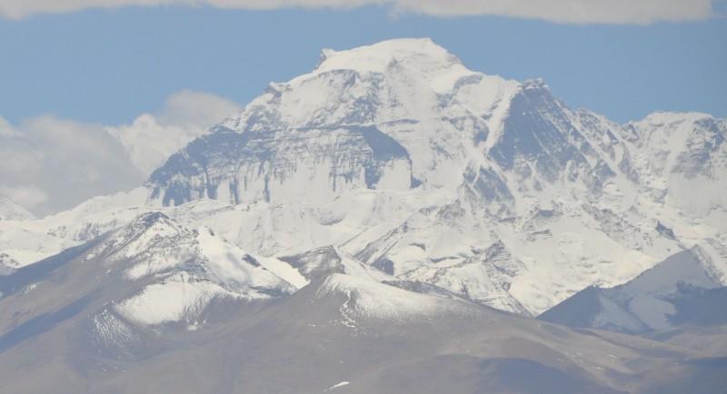
The landscape on the way up to the Gyalwul Pass (5250m) is stunning with expansive brown treeless plains dotted with few Tibetan houses, valleys and some snow-capped mountains. The construction of this highway is a great engineering achievement. We had our first view of the Himalaya range at the Pass. On a clear day, one can see a huge sweep of the Himalaya range including peaks over 8000m i.e. Makalu, Lhotse, Qomolangma and Cho Oyu. We saw all clearly except Makalu and Lhotse. We passed a couple of Tibetan villages before arriving at the Rongphu Monastery, the world’s highest monastery at 4980m. At 4pm, we finally arrived at the base camp (5200m) where there are dozens of tourist tents.
 |
 |
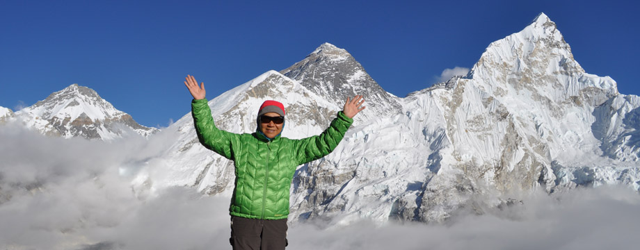
After a short rest, we took another tourist bus heading for a lookout area at the base camp some 3km from the tents. I have seen the south face of Mt Qomolangma from Kala Pathar (5545m) in Nepal last November. But the full view of the north face of the mountain is much more impressive and beautiful as it stands out majestically on its own.


Sunset
Despite the cold weather and the strong winds, I went out with Gen Yao and Shi Young with our cameras to watch sunset around 8pm. It was not too cloudy but we did not have a gorgeous sunset. I had a light headache and no appetite and vomited a couple of times. These are symptoms of mountain sickness. My condition was comparatively mild. Gen Yao had not been able to sleep since arriving in Lhasa two days ago and had a bad headache all the way. He also had to inhale oxygen from a bottle the whole night.
In Nepal, trekkers normally take some 10 days to reach the Everest Base Camp. But in Tibet, people go there by car thus ascending from about 4000m to over 5200m within a couple of hours. As a result, it is difficult for the body to adjust. The highway has opened the sacred Mt Qomolangma to mass tourism. While I enjoy the full view of the north face of the mountain, I find my long trek to the Everest Base Camp in Nepal more satisfying and memorable. Trekking allows time for one to soak up the Himalayan atmosphere and enjoy the magnificent scenery.
May 17: Mt Qomolangma Base Camp – Shigatse (about 7 hrs)
We got up around 6am to watch sunrise. But it’s too misty. What a pity! I hope to return to the base camp on a trekking tour one day.
We departed for Shigatse at 7am. As I was tired, I slept most of the way back to Shegar where we had lunch. My original plan was to leave the group to make my own way back to Lhasa. But they asked me to stay as they had a spare seat anyway. I fully appreciate their good will and generosity. They took good care of me as I am some fifteen years older!
 Shigatse is the second largest city in Tibet and famous for its Tashilumpo Monastery. Built in 1447 by the first Dalai, a disciple of Tsongkhaba, the founding father of Gelugpa, the monastery is the biggest one for this school of Lamaism (i.e. the “Yellow Sect”). As the seat of the Panchan Lama, the stupas of the 5th to 10th Panchan Lama are found in the monastery. The world’s highest seated Maitreya Buddha is located in the central hall. There are two annual major festivals and the Buddha Unfolding Festival is a particular draw for thousands of Buddhists and tourists.
The monastery has smartened up a lot since my last visit in 1995. It is clean and the pilgrims are well-dressed in traditional Tibetan costume. Inside the halls, one no longer finds smoke and strong smells from the butter lamp. On my last visit, some of my friends got sick as they could not stand the smell. According to the guide, the butter now used for the butter lamp is environmentally friendly in order to preserve the precious mural paintings on the walls.
 |
 |
 Taishilumpo Monastery |
In the evening, Gen Yao hosted a dinner and we had a local specialty i.e. chicken soup in a ‘Motuo’ stone pot. Gen is a businessman and comes to Hong Kong often. I hope to take him and his wife out for a seafood dinner in Hong Kong one day.
May 18: Shigatse – Lhasa (360km; 6 hrs)

Yamdoktso Lake
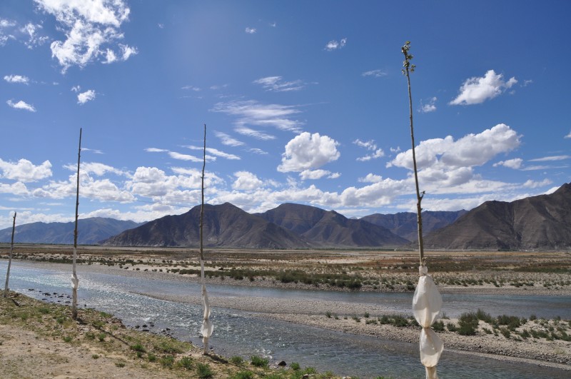
As usual, we set off at 7:30am and had lunch around 11am. We drove along the famous scenic route along the Yamdoktso Lake (4400m above sea level), one of the three holy lakes for Tibetans. The lake covers some 800 square kilometres with a hydro-power plant at one end of the lake. Tibetan villages are scattered along both sides of the lake. We were captivated by the stunning scenery with reflections of snow-capped mountains, white clouds and blue sky in the sapphire blue lake, green fields, horses, yaks and sheep grazing on the grassland by the lake. It is unearthly beautiful. Suddenly it started snowing and we all got excited. I could not stop taking photos which look like Chinese ink painting. We passed numerous passes including the Gyatsola Pass and Pangla Pass.
 Dzong ruin in lake |
 |
") |
 |

Dzong ruins,Gyantse
We had a brief stop in Gyantse, the fourth largest city in Tibet and often referred to as the ‘hero city’. We took pictures of the Dzong Ruins, parts of which dated back to 14th century B.C. from a great distance. There is also a commemorative plague for those who died in the 1904 battle between Tibetans and British troops. I love to visit the Palkor Monastery, Kumbum Stupa, Samya Monastery and Sakya Monastery in the region and shall return to see these places one day. We finally arrived in Lhasa around 2pm.

Hot pot
It’s my turn to host a dinner for my nice friends. Gen Yao, Lin Mang and Du Fi joined while Shi Young and Zeng Rong went for last minute shopping. We had a delicious mushroom hot-pot dinner. Du Fi comes from Sichuan and runs his own tour company. He is lively and most efficient. I asked him to arrange a 2-day trip to the Namtso Lake, a 4-day trip from Lhasa to Ranwuzhen and get a plane ticket to Beijing on May 25.
May 19-25: Lhasa
Lhasa is normally warm in May and only rains during the night. But the weather has become abnormal: it rained heavily the whole night and did not stop till 3pm. As a result, the 2-day trip to the Namtso Lake was cancelled. I spent the whole day in Du’s office catching up with my emails. I moved to the hotel where his office is located on the Sun Island next to the Lhasa River.
In late afternoon, Du took me to an ATM and drove Gen to the Sera Temple. As I had time, he suggested I go with Gen. I had visited this temple but was delighted to see it again. Built in 1419 by a disciple of Tsongkhaba, it is small, more atmospheric and intimate. It is at the foot of a hill with winding paths with smaller but colourful buildings (orange, blue, yellow and white) and walls with round corners. I left my camera in the hotel as I did not know I would go sightseeing. As the main halls are closed for restoration, there were no tourists except some pilgrims.
Du dropped us near the Barkhor Street and I spent two hours strolling along the iconic street and walked past the holy Jokhang Temple. The place has changed a lot since my last visit: it is now filled with shops and the pilgrims look smarter and well-dressed. There are many eateries and I had a big flask of sweet tea for 3 yuan in a local tea house. The Tibetan customers looked friendly and tried to talk to me. I could only smile in return. They must think I am an idiot.
May 20-23: Lhasa- Bayi town – Ranwuzhen – Bayi town – Lhasa (1700km)
Chinese love travelling. It is now popular for Mainlanders, especially the young and the adventurous people to travel on their own all over China. There are numerous local tours available in Lhasa. The more popular ones include a 4-day trip to Mt Qomolangma Base Camp or a 5-6 days to Zhangmu/Kodari; 1 or 2 days to Namtso Lake; 2-3 days to Yarlung Valley and 4 days to Ranwuzhen.

Our car
I paid 1800 yuan for a 4-day package tour from Lhasa to Ranwuzhen which is not cheap. But having taken into account the high fuel cost, the long distance, high entrance fees for the attractions, I consider the rate acceptable. I travelled in a 4 wheel drive with three young people from Zhangmen, Guangdong. But the driver is a problem: he has no social skills and does not say a word. He did not specify the length of time we should spend on an attraction. As a result, by the time we reached the Kading Scenic Area on the first day, it was already 7pm and the park was due to close in fifteen minutes’ time.
We spent the first and the third night in the Bayi Town and the second night at Ranwuzhen (3950m) by the Ranwu Lake. On the second day, a mother and her daughter from Dalian boarded the vehicle after their visit to the Yarlong Tsangpo Grand Canyon. The 496-km long canyon with an average depth of 5000m and the deepest point at 5382m, has an area of 17,000 square kilometres with 17 snow-clad peaks over 6000m. There is an enormous and most photographed bend and the river drops drastically to 155m. The entry fee is however very expensive (over 800 yuan). I shall go if I can spend a week hiking in the reserve.
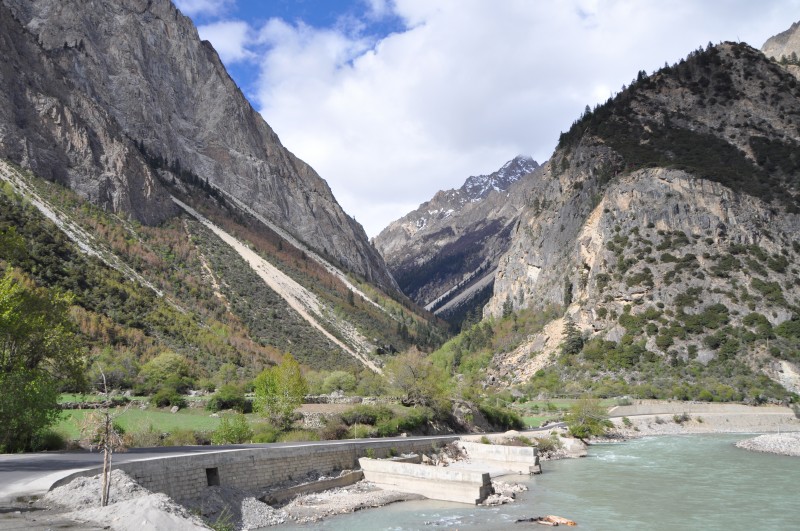
We spent most of the time in the car covering an average of 400 kilometres a day. The scenery and landscape with forests in full array of spring colours, high mountains with snow-capped peaks and many passes over 5000m, deep gorges, fast flowing rivers and numerous glaciers are breathtaking. The tarmac highway built along very difficult terrain has mostly been completed. The numerous tunnels and slope stablisation works are impressive. It is so much easier to travel in Tibet these days compared to my previous visit. However, there is still an unpaved, very narrow and steep section connecting Pailung to the great turning of the canyon and Motuo which is said to the most dangerous highway in China. It is a natural barrier full of landslides, cave-in and other disasters.
 |
 |
 Birth place of Tsongsa Gompu |
 Mila Pass
|
 |
During these four days, we visited a number of attractions in the Nyingchi Prefecture which has been described as Tibetan Switzerland.

Basomtso Lake
Basomtso National Park located 370km from Lhasa, is a holy lake of the Nyingmapa order of the Tibetan Buddhism. The scenery of this green 15-km long lake with an area of 26 square kilometres is comparable to those in Switzerland.
Midui Glacier in Bome County is a monsoon marine glacier and the world’s lowest glacier ranging from 2400m to 6800m. The China National Geography has named it as ‘one of the top six glaciers in China’. It is easily accessible. The scenery is breathtaking with snow-clad as well as rocky mountains, glaciers, forests, lakes, villages and temples, green fields under cultivation, herds and rivers.
Ranwu Lake at 3800m above sea level is the largest lake in southeast Tibet with an area of 22 square kilometres. It is scenic with the Gangrigabu Snow Mountain in the southwest, the Azhagongla Glacier in the south and the Bosula Peak in the southeast. The lake has sky-blue water and green grassland around it.
 Ranwu Lake |
 Heavenly Buddha Waterfall |
 Midui Glacier |

2500-year old cypress
The Giant Cypress Reserve near Bayi Town has hundreds of cypress trees with an average height of 44m. The 2000-year old cypress king at 56-m high with a chest diameter of 6m is regarded by locals as’ God of Tree’. The trees are noted for their huge tree crowns and upright trunks.
But the most memorable part of this trip is not the sights/attractions but the scenic drive along National Highway 318, a 5476-km long highway from Shanghai to Zhangmu and Nepal. Some 2000 kilometres of the highway are located in Tibet. During my 11 days in Tibet, I travelled some 1500km on Highway 318 and have seen the most spectacular scenery at the Milha Pass, the zigzag road winding up/down the mountains, virgin forests near Lulang, Tibetan villages, pasture land, soaring snow-clad mountains, hanging glaciers, deep gorges, lush forests, rivers and rapids. Landslide is however a problem and I am impressed by the painstaking efforts to stabilize the slopes. There is ongoing work on several tunnels and some parts of the road are being widened. I find travelling on the ‘Sky Danger’ section most scaring though the scenery is most dramatic and stunning. We were stuck twice as a result of traffic congestion. Unless something can be done to widen and perhaps have the road paved, the congestion situation will worsen as more long goods and passenger vehicles will be using the National Highway 318.
 |
 |
 |
 |
 |
 |
 Slope stablisation |
 |
May 24: Lhasa – Namtso Lake

World's highest railway line
I took a day-trip to Namtso Lake, the world’s highest lake at 4718m with an area of 1920 square kilometres. I had to get up before 5:30am as a guide would pick me up at 6am. But the 55-passenger bus did not set off till 6:45am. What a waste of time!
We had two brief photo stops at Yangpachen thermal power plant and the Nyenchen Thanglha mountain range. But when we arrived at the entrance gate of the Namtso scenic area after 3-hours driving, we found the park closed due to icy road condition. Some 40-50 vehicles of all sizes were turned away. Hoping the park would be open later in the day, the guide arranged us to have an early lunch at Damxung. Unfortunately, the park remained closed at noon and we had to return to Lhasa. I am most disappointed. C’est la vie!

Sunset at Potala Palace Square
The Potala Palace Square and the Palace are lit up around 8:30pm every night. I went to the square to watch sunset and the lighting. To my dismay, loud blast of music completely destroyed the atmosphere. If the authority considers the lighting should be accompanied by music, they should go for some soft background music. I suppose most overseas visitors prefer a peaceful and relaxing atmosphere without music at all.

Palace at Sunset

Palace in floodlight
May 25: Lhasa- Beijing (by air)
My flight was scheduled for departure at 4pm. I spent the whole morning at Barkhot Street including two hours at the 1300-year old Jokhang Temple, a World Heritage Site. Construction started in 647 A.D.; the four-storey temple faces west. There are many chapels inside the central hall on both the first and second floors. Pilgrims line up in an orderly way to go to the chapel where the statue of a 12-year old Sakyamuni brought by Princess Wencheung from China was placed. I visited the temple in 1995 but could hardly remember how beautiful it is. This time, I wandered from chapel to chapel soaking up the atmosphere and appreciate the religious arts. Religion is part of the Tibetan life and I was moved to see pilgrims prostrating, chanting, praying and lighting the butter lamps. The atmosphere is enchanting and spiritual. I strolled along the Barkhor Street and had butter tea, yoghurt and noodles for lunch before departing for the airport.
 |
 |
") |
 |
 I took the airport bus to the airport which is some 60kms away. It runs every 30 minutes and the fare is only 25 yuan. I was at the old airport 15 years ago when there was only a flight a day to Chengdu. The new airport is modern and handles dozens of flights a day. When our flight was cancelled owing to windy conditions, we had no alternative but to stay in a smelly and dirty guesthouse next to the airport provided free of charge by the airline. In those days, we had to pay as much as 2000 yuan one way for a tourist bus to return to Lhasa. Life is totally different now!
I am surprised there is no direct flight to Beijing, the capital. All flights have to stop either at Chongqing or Chengdu. My flight via Chengdu was delayed and I did not arrive at the Beijing airport till 10:45pm. I waited 40 minutes for my luggage and had to take an airport bus to town instead of a taxi as there was a very long queue. By the time I arrived at my hotel, it’s close to 12:30am. What a long day!
Remarks
Tibet has changed a lot since my last visit in 1995.The infrastructural developments especially the highways, are impressive especially after my stay in Nepal. It’s difficult to imagine 20 years ago that Mt Qomolangma Base Camp at 5200m would become a hot destination for mass tourism. Both local and overseas tourists are flocking to Tibet given the improved railway, road and air links to Tibet. But I hope Tibet can escape the negative impacts normally brought about by such an onslaught of tourism.
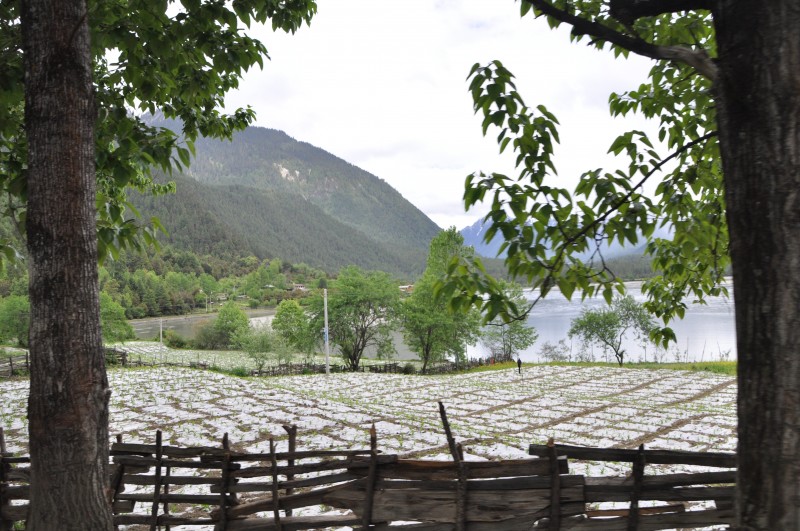
Shigatse has developed beyond recognition and is much greener now. Both Lhasa and Shigatse look smarter, more prosperous and cleaner than before. Tibetans now enjoy a higher standard of living. Food and goods from all over China are easily available though they are not cheap. I note extensive greenhouse farming along the river plains.
There are still many places I want to see in Tibet. I shall make my third visit in August to Qinghai and then go to Lhasa by rail. My ultimate destination is the Ali Prefecture where I can visit Mt Kailash, Lake Manasarova and the ruins of the Guge kingdom in western Tibet.
Utterly overwhelmed by the plethora of places names ( I google the equivalent chinese names and maps as I read along), your beautiful photos and very detailed informative record of the places you set foot on in this ‘short’ trip – you make me feel as you had traveled around the world twice in these 11 days. Most envious.