

Mt Kailash (Holy Mountain), Lake Manasarovar (Holy Lake)and Yerngo Monastery ruin

Namtso
Meanwhile I took a 2-day trip to Namtso 纳木措, the world’s highest lake (4700m) with a water area of 1940 square kilometres. This was my third attempt to see this “heavenly lake”. At 2pm on August 18, I together with eight passengers including Will, a young man from Hong Kong, left Lhasa in a small and uncomfortable van. Will had cycled on his own for 20 days from Xining to Lhasa. I am most impressed by his stamina and adventurous spirits. I paid an entry fee of ¥120 and arrived at the Zhashi Peninsula 扎西半岛 just before 7pm. I shared a room with three frugal Mainland tourists and paid ¥25 for a bed!
 |
 |
 |
 |
 I spent almost two hours walking along the lakeshore following three Tibetan pilgrims. The rock formation is impressive and there are numerous caves strewn with prayer flags. One of the caves is said to have been dwelled by Milarepa (11th-12th century), the great Tibetan saint, who had also left a handprint. There is a cliff strewn with numerous khatags (silk ceremonial scarves). Though there was no spectacular sunset, my eyes were suddenly caught by a fire red sinking sun behind clouds, which seemed to come out from nowhere! I took a few photos before it vanished as fast as it had appeared.
At 9am, our driver Xiao Jiao小焦 picked us up in a Mitsubishi land cruiser, and we signed an agreement on the car hire. Xiao Jiao in his forties is a soft spoken and neatly groomed person with a nice smile, and does not smoke (Brenda forbid anyone smoking inside our car). He was wearing a stylish beige colour jacket休闲服and a pair of business shiny black leather shoes. He does not look like a chauffeur/driver驾车师傅. (We found out later that he had never gone beyond Xigase and could not even read the map, and was obliged to take up the job as his brother, owner of the car hire company, could not find a suitable driver!)
 Yamdrok Tso |
 Baijusi |
I sat next to Xiao Jiao while Brenda was busy with map-reading at the back. We made several stops including the lake Yamdro Yumtso羊卓雍措 (4488m). I saw this lake in May but it looked much greener and more lively this time with lamas performing religious rituals by the shore. We had lunch at the ancient trading post Langkatze 浪卡子,passed the picturesque Manga Reservoir 满拉水库 and arrived at the Pelkhor Chode Monastery 白居寺in Gyantse 江孜城 around 4pm.

lakeside ritual
This monastery was constructed in 1418 by a local chieftain Rapten Kunsang and Kadup Gelek Pasang (the 1st Panchen Lama). It is famous for its monumental nine-tiered chorten 白居塔 standing at 32.4m high with some 108 cells containing 100,000 mural paintings and holy images. There are many impressive statutes. The setting is both amazing and atmospheric.We arrived at Xigase (3900m) around 8:30pm. Though I had taken the same route three months ago, I enjoyed the landscape and scenery just the same.
Day 2: Xigase日喀则 – Sakya萨迦 (about 70km)

Nathang ruin
On the way to Sakya (4280m), we visited Narthang Monastery纳唐寺 which once had some 10,000 monks and was a centre of learning as well as the place where the Tibetan Buddhist canon 大藏经 and many other scriptures were compiled and printed. The site is mainly a ruin now though some woodblock-printed scriptures and carved woodblocks are still kept in the monastery’s assembly hall. There was once an impressive cluster of 13 chortens nearby, but they were sadly destroyed during the Cultural Revolution. Though this monastery is next to the main highway, few visitors stop to take a look at this historically significant place.
–
At 4pm, we arrived at the monastic town Sakya, seat of the Sakyapa school of Tibetan Buddhism 萨迦派, and emerged as an important centre of religious study in the 13th century. With the support of the Yuan dynasty元朝, the Sakyapa lamas became rulers of Central Tibet for a brief time.

Thangka painting
 The monastery complex is divided into two parts. The North Monastery 北寺was established by Khon Konchok Gyalpo in 1073 while the south one by Sakya Sangpo in 1268.
Tsongkhapa Hall
While we were visiting the monastery, Xiao Jiao offered to find suitable accommodation for us. To our dismay, he paid ¥240 for three beds in an appalling “room”板间房without toilet in a guesthouse招待所. We argued with the cunning owner and managed to get ¥140 back. While Xiao Jiao stayed in the guesthouse, Brenda and I moved to the Sakya Hotel which charged us ¥180 for a standard room with bathroom. We were furious with Xiao Jiao who is ignorant and does not seem to know the normal cost for a bed in a guesthouse of low standard. He should never have paid without first seeking our consent.

Northern Monastery (F); Southern Monastery (B)
We explored the sprawling compound including the Northern Monastery and ruins of some palaces on the hillside across the river. Brenda was bothered by altitude sickness and preferred a shorter walk. I therefore went on my own to see all the ruins and followed the pilgrimage route passing through many chortensand prayer flags along the way.

The Hermitage

Preparing droma
The hermitage开悟寺 with some 40 monks perched on a cliff is picturesque. I watched them preparing dorma 朵玛(sacrifice cakes) which is made with tsampa 糌粑(barley flour). The nunnery nearby has some 20 nuns. We gave a lift to a monk to the Sakya Monastery and arrived in Lhatse 拉孜 (4050m) around 7 pm. A wonderful and relaxing day!
Day 4: Lhatse拉孜 – Tingri定日- Mt Xishabangma National Park希夏邦马国家公园- Saga萨嘎 (over 300km)

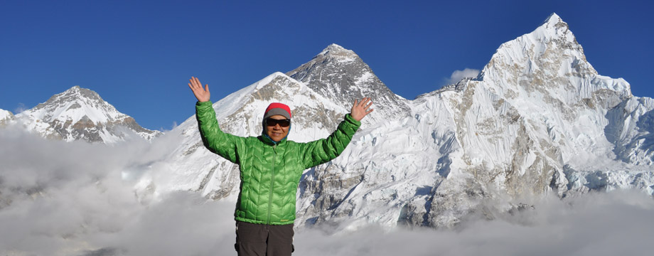
Mt Everest
Instead of going west taking Highway 219 to Saga萨嘎, Brenda suggested we take a southwest route to Tingri定日and then stay overnight at Kirong吉隆which for many centuries was an important stopover and market town along the Tibet-Nepal-India trade route. On the way to Tingri we had a fantastic view of Mt Everest and the other high peaks.

Old Tingri
There are two Tingri. The new one is off Highway 318 (also known as the Friendship Highway from Shanghai上海 to Zhangmu樟木on the border with Nepal) while the old one is next to the highway. There is not much to see in the new Tingri (4390m) and we stopped at the old Tingri for lunch.
In the afternoon, Brenda searched the places which are connected with her research. We left Highway 318 and passed through Mt Xishabangma 希夏邦马 (8012m, 14th highest in the world) reserve area which charges ¥65 per visitor. The road is good without traffic and the landscape is gorgeous. The snow-capped peaks including those of the Langtang range from the Nepal side seem so close that I wish I could spend a couple of days hiking in the area. The scenery with vast grassland, numerous lakes including the large salt lake Pelkutso 佩枯措(4591m) is most impressive. We also saw a pair of cranes and some kyang (Tibetan wild ass).
 |
 |
 |
 |
We thought we were making good progress till we reached a junction with one road to Kirong and another to Saga 萨嘎(4600m). The road to Kirong is under repair and was closed till 7:30pm. Instead of waiting for an hour, we decided to turn north to drive to Saga.
The winding dirt road is steep, bumpy and without directional signs. It rained and Xiao Jiao was getting anxious to reach Saga before sunset. As we climbed further, Brenda started to have altitude sickness symptoms again. We finally got there around 8:30pm and stayed at the Saga Hotel which is popular with Hindu pilgrims.
Day 5: Saga 萨嘎 – Darchen 塔钦 (about 500km)

 Landscape changed to barren brown hills, sand dunes and grassland. We drove westward the whole day on Highway 219 with only a brief stop at the 400-year old Darjeling Monastery 昔日达吉岭寺in the morning and a lunch break at Zhongba仲巴. It is a new town where the main roads are still under construction and public facilities seem lacking. The toilets are most terrible with sanitary napkins, tissue papers and rubbish piling up to over a foot-high. (I was bitten by some sort of bugs/fleas and I discovered an infection on my right ankle the next day. Brenda also found infection caused by flea bites around her waist).

First sight of Mt Kailash from Darchen
At 7:30pm, we arrived at Darchen 塔钦(4575m), a small town in front of Mt Kailash and close to the starting point for the Mt Kailash circuit. We stayed in a guesthouse run by a teacher from Beijing. I was surprised to find free wifi and hot-shower (bathroom is located outside), but electricity is available only from 9pm to midnight.
 |
 |
 |
 |

Chi'u Temple (top)
The only solution was to return to Darchen to find a chain. As the other car had only a passenger, Brenda, Xiao Jiao and I could get a lift back to Darchen. Brenda was totally exhausted and had to stay at the guesthouse. After finding a helping hand and a steel rope, the driver drove his friend, Xiao Jiao and me to the lake. Finally they managed to pull our vehicle out of the sand and put it back on the paved road! They charged us ¥400 for the operation and Xiao Jiao asked me to pay. (I do not see why we should pay for this. If his 4-wheel had functioned properly, he would have got out of the sand without problem. If he had a steel cable with him, the other vehicle would have already pulled his vehicle out. When later on I told the travel agent Xiao Du about this, he returned us the money.)
On our way back to Darchen, I asked Xiao Jiao to stop at the Chi’u Monastery 齐乌寺overlooking the Holy Lake from a cliff. It was built upon the cave where Milarepa had once meditated. I followed a group of pilgrims into the main hall which is usually locked up. I got back to Darchen about 6pm. What an eventful day!
 |
 |
 |
 |
Day 7-8: Kora around Mt Kailash 转神山
All visitors are required to buy a ¥120 ticket for entering the Mt Kailash and Lake Manasarovar area. Xiao Jiao dropped me and my 19-year old Tibetan porter off at the Prayer Flag Square 经幡广场 which is 4km west of Darchen. I walked along the Lha-chu valley 拉龙沟and had my first sight of Mt Kailash above the eastern ridge. I also saw the Chuku Monastery 曲古寺 (4820m) perched high above the valley but decided to give it a miss. My porter showed me the Buddha’s Footprint.
On my way to the Dira-puk Monastery 哲日普寺, I met two Tibetan pilgrims from Gar噶尔 (Shiquanhe 狮泉河) and their three porters. I took about 4 hours completing 16km with 200m ascent to reach the monastery which affords superb views of the northern face of Mt Kailash and three lesser peaks believed to be the celestial abodes of Chagna Dorje 金刚手(Vajrapani) to the west, Jampeyang 文殊 (Manjushri) to the east and Chenresig 观世音(Avalokiteshvara) in the centre. The Kangkyam Glacier descends from Mt.Kailash, between Chagna Dorje and Chenresig.
 |
 |
 |
 |

The Tibetan pilgrims invited me to join them for lunch. We had butter tea, eggs, mutton and tsampa. After a good rest, we set off again around 4pm. The ascent from the Drolma-chu Valley to Drolma-la 卓玛拉山口 (5630m, highest point of the circuit) is steep in some parts. I passed Shiva-tsal, a rocky area dotted with stone cairns draped with all sorts of personal belongings. I put the khatag given to me in Qinghai on a rock facing Mt. Kailash. I am a slow hiker and took four hours to reach the pass. I saw Gauri Kund 托吉措 (Lake of Compassion) (5608m) where Hindu pilgrims are supposed to immerse themselves in the water. As the weather was not too good and would get dark quickly, I lost no time and made the 400m descend to the grassy bank of the Lham-chu Khir river valley within an hour. As I was in a rush, I missed the footprint of Milarepa. It was 9pm when I reached the tent.
 |
 |
 |
I could not believe I had covered 26km and reached the highest point in my life at Drolma-la! The Tibetans arrived an hour earlier and already had their dinner. There was enough hot water for only one cup-noodle. I told my young lady porter to have a cup noodle while I had some bread. I went to bed with an empty stomach!
There were nine people sleeping in the tent. Each had to pay ¥40 for a bed space. As I cannot stand the strong butter and body odour, I chose a space next to the exit where there was a steady flow of fresh cold air. I also used my own sleeping bed. I did not sleep well and woke up around 6am. As my porter was fast asleep, I waited till 8am when they were all ready to start.
 |
 |
 |
 |
The 22-km walk was relatively easy. We followed the Lham-chu Khir river valley and had breakfast with butter tea, mutton, eggs and tsampa in the sun around 10am. We passed the Zutul-puk Monastery 祖楚寺 without stopping as my companions did not consider it worth seeing. The path is fairly level and well-maintained but the scenery is not as spectacular. We stopped again at a tea-house at the ticket-check point before descending to Darchen. When I arrived in the guesthouse shortly after 3pm, everyone was surprised that I was back so early and without signs of exhaustion!
I heard about the Gyangdrak Monastery江扎寺 which is not far north of Darchen and ask Xiao Jiao to take us there. It is a short but scary drive as the road which is under construction, is steep with many sharp bends. The monastery affords superb views of the whole area including Lake Manasarovar. (While I was away on the Mt. Kailash kora, Brenda visited Lake Manasarovar, Purang the ancient Tibet-India trade post, and the thousand-year-old Korchag Monastery科加寺 close to the Tibet-Nepal border.)
Day 9: Darchen 塔欽- Namru 那木如 – Zada 扎达 (about 350km)

Guge Ruins
Our next destination was Zada 扎达 (3770m). Brenda’s map seems not updated. It shows a side road turning west to go to Zada from Namru 那木如, a village on the Highway 219 some 70km southeast of Gar. When Xiao Jiao asked for direction, he was told to follow the Highway and turn left (west) at Ba’er Barrack 巴尔兵站.
We were confused by the road signs and we passing Ba’er巴尔 without noticing the barrack. Afterwards one sign told us to go ahead and another indicated a right turn. Xiao Jiao who is not an attentive listener, was not sure about the information he had obtained about the road to Zada. As a result, we relied on Brenda’s map and had a long drive to Namru, got over a mountain pass at 5320m (even higher than the Mt Everest Base Camp) and a couple of mountains before descending to the small town Shangtse 香孜, which was once an important stop on the Tibet-India trade route, with an impressive fortress on a ridge.
We then met a young police officer who was on his way to see his family in Zada. We offered him a lift. There was hardly any traffic or road sign on this off-beat track! But the earth-forest landscape and scenery with desert canyons and eroded mountains土林景观 are amazing. We finally safely reached Zada at 5:30pm. We had an early hot-pot dinner in the restaurant opened by the officer’s Sichuanese parents. What a day!
Day 10: Zada扎达
The great Guge king Yeshe Od sent the young monk Rinchen Zangpo (958-1055) to study in India. The monk returned 17 years later to become one of Tibet’s greatest translators of Sanskrit texts and a key figure in the revival of Buddhism in Tibet. He built 108 monasteries throughout Western Tibet, and Ladakh 拉达克 and Spiti in North India. The most important ones were those at Tholing and Tsaparang. The kingdom fell into ruin in late 17th century.
 |
 |
 |
Tsaparang etched into the side of an imposing ridge is a most amazing site! One must see it to fully appreciate its beauty, magnificence and the difficulties in constructing it some 1000 years ago. There are three distinct areas. At the bottom one finds the monastic areas with four buildings all of which are under restoration. There is a residential area in the middle level and then a tunnel through the hillside leads up to the palace citadel at the very top of the hill. From the top, the views are breathtaking. The earth forests stretch out hundreds of kilometres on the other side of the river. There are also beautiful earth mountains on the side and at the back of the citadel! The tiny palace is under restoration. The ruins at the top can be dangerous for visitors as there are many holes and broken steps and part of the walls have collapsed. Brenda was bothered by altitude sickness and vertigo and thus only managed to climb up to half the height. There was no tourist and I enjoyed the unrivalled scenery in peace!
 |
 |
 |
 |
The Tholing Monastery 托林寺 was once Ngari’s earliest and most important monastic complex. There were once some 300 stupas all over the area. But today, one finds only a few dozens of stupas surrounding the monastery which has only the main assembly hall 经堂 (dukhang) (also known as the Red Hall 紅殿), Yeshe Od’s mandala chapel (Namnang Lhakhang) also known as the Gold Chapel 色康佛堂 (the White Hall白殿) and the Gyatsa Lhakhang 迦萨殿 which is now a mini museum. The mural in the White Hall is more impressive than those in the Red Hall which is too dark to be seen. A monk showed us around the Gyatsa Lhakhang and into some of the side-halls in honour of Sakyamuni, Medicine Buddha and Rinchen Zangpo (the great translator). All the statutes have been destroyed during the Cultural Revolution.
 Prayer wheel, White Hall |
 Tholing Monastery |
 Sunset at Zada |
The achievements of the Guge Kingdomas exemplified at Tsaparang and Tholing Monastery are impressive. In my view, the stunning landscape of the earth forests, Tsaparang and the Tholing Monastery merit a listing as a Natural and Cultural site on the World Heritage List.

Piyang caves
Day 11: Zada扎达 – Piyang皮央 – Dongga东嘎 – Zada (about 100km)
 The Piyang and Dongga caves 皮央东嘎洞窟 are the largest ruins of Buddhist caves discovered in Tibet. In the period of great prosperity, there were over 2,000 caves. Their heyday more or less coincides with that of the Guge Kingdom. We drove some 60 km to Piyang. Numerous caves appear on the rocky face high up on a cliff.
 We met an 18-year old Year I university student in Lhasa who speaks Putonghua. She helped us find Grandpa Rinjin, the key holder for the caves. Only two caves are open to public. The caves have a tall ceiling painted with beautiful Buddhist images. Around the walls are well preserved and beautiful mural paintings featuring mandalas, Bodhisattvas and many other Buddhist images. One cave has a statute of the great translator Rinchen Zangpo. The dukhang 经堂 outside the caves is now empty with thousands of pecha (Tibetan-style scriptures) scattered all over. We understand the pecha is old and original (later we were told by Professor Tsering Gyalpo of TibetUniversity that they were over a thousand years old). I hope something can be done to preserve them.
Mom and daughter
I am keen to see a typical Tibetan home and our young guide took us to her house. As her father has passed away recently, her mother stays on her own in the village while her 25-year-old brother works in Zada. The house is large with a spacious living with potted flowers on the window sills. I had two bowls of delicious homemade yogurt and several cups of butter tea. As a trip costs ¥600, she cannot afford to come home every year. It was her first trip home in four years. I encouraged her to study hard and gave her some money so that she might be able to come home to see her mother next year.

Dongga
Day 12: Zada 扎达 – Ba’er 巴尔 – Qulong (Khyunglung) 曲龙 – Menshi门士(about 250km)
We wanted to take an off-beat path to see Manang Monastery马朗寺, Daba Monastery达巴寺, Dongpo Monastery东坡寺 and Qulong (Khyunglung)曲龙 south of Zada city. Xiao Jiao was most reluctant to take the dirt road but had to take our instructions. As there is no road sign at all, we decided to follow the power line for some 30km. Unfortunately we found ourselves on the wrong track and approaching the Sino-Indian border. We had to abandon our plan and return to Zada.
 |
 |
 |
 |
After lunch, we took the newly constructed road (which is also called Highway 219) to the Ba’er Barrack (which is at the no.1192 milestone on the Highway 219 to Ngari). I find it most absurd to have two different highways using the same number ‘219’. We followed the so-called Highway 219 and then the authentic Highway 219 to Menshi 门士, and then took a dirt road to Qulong 曲龙银堡 which was the capital of the legendary Zhang Zhung Kingdom象雄王国.
 |
 |
Fifteen centuries ago in its heyday around 15 centuries ago, the territory of this kingdom is believed to have extended from as far west as Iran to Eastern Tibet. The route is scenic. The hillside has many caves which were once inhabited by monks and yogins. We also drove through a picturesque narrow gorge planked with mountains and rocks. Unfortunately, we had wasted so much time in the morning that it was already 6:30pm when we reached Qulong. The sun was setting and temperature dropped rapidly. Brenda found her body temperature dropping as well and there were signs of trouble. We rushed back and did not have time to visit the massive castle and the monastery. We spent a night at the small roadside town Menshi 门士 and Brenda did not sleep well.
Day 13: Menshi 门士 – Gar 噶尔 – Darchen 塔钦 (about 600km)
We could take the same route back to Lhasa (about 1200km) or the longer northern route across Northwestern Tibet via Gar. Xiao Jiao enthusiastically proposed the latter. So we drove to Gar (4280m), seat of the Ngari prefecture.
At Gar, Xiao Jiao stopped at a garage for minor check and repair. When he was told about the inferior road condition ahead, he changed his mind and refused to take the northern route. We were furious with him for the second time. He should have found out the latest road condition before proposing the northern route. He had wasted our time and money as we had to pay for an extra day, car rental and gas.
We spent five hours on Highway 219 driving some 200km back to Darchen. For most of the time we drove through on and off rain and for a while flakes of snow. Outside temperature dropped to almost freezing point, and rose again only when we were approaching Darchen. As fate has brought me to Darchen again, I decided to take this opportunity to circumambulate Lake Manasarovar. I told Brenda to return toLhasain Xiao Jiao’s car taking my luggage, and I would take a bus toLhasaon completion of my hike. This would be most economical and Brenda would not need to hang out for another few days in Darchen.
Day 14-15: Lake Manasarovar kora 转圣湖
After spending one night in Darchen, Brenda and Xiao Jiao dropped my porter (a 22-year old Tibetan guy this time) and me off at the ticket check-point at Hor 霍尔乡. It was a cool, cloudy but pleasant day. I had a brief stop at the Seralung Monastery 色瓦龙寺 belonging to the Sakya sect.
 |
 |
 |
 |
 |
 |
 |
 |
During my nine-hour walk covering about 30 km, I met eight Tibetan pilgrims from Nagqu. They invited me and my porter to share their food (homemade bread, tsampa and dried goat meat). They would complete the kora without stop. I also saw a large group of Hindu pilgrims travelling in their 4-wheel drive (some 20 vehicles) and eight Tibetans travelling on four motorbikes. The scenery is pretty but not extraordinary. The lake was smooth and calm. The silence was only broken occasionally by noises coming from the 4-wheel drives and motorbikes.
When I passed by the ruined Yerngo Monastery 聂果寺 on the southeastern end of the lake, I sighted the pinnacle of Mt Kailash which had been behind clouds the whole day. I finally reached Trugo Monastery 楚果寺 on the southern end belonging to the Gelugpha order at 7:30pm. The sunset was not great as it was too cloudy. But when I looked across the lake at Mt.Kailash, I suddenly had the feeling that “I have reached the other side 我到彼岸了!”.
There was no electricity. I lit up my room with a candle. I found the scenery a bit monotonous and decided to walk for another 25 km or so to the highway to catch a car/bus at Barga 巴噶 the next day. I could then reach Lhasaon September 6, the same date when Brenda returned toLhasa.

Rainbow, sunrise, Trugo Monastery
It rained heavily the whole night. I got up around 8 am, but there was no sunrise to see. Instead, I saw two rainbows. The scenery was bleak but serene; the nearby mountain tops were all snow-white while dark clouds hovered over the Lake. I paid ¥70 for two beds. The keeper kindly offered us butter tea and tsampa (without charge). For the first time, I found the tsampa tasting not too bad (perhaps because I was cold and hungry). I thanked him for his kindness and gave him some biscuits and sweets.
 Owing to the heavy downpour of rain, we had problems crossing the streams. Hence, I took three hours to reach the southern tip of the lake. It was a quiet day and I only saw a few vehicles passing by a long way from the lake. But I did not come across more pilgrims. Around 2:30pm, a minivan passed by. My porter urged me to take the van to Barga as I might not be able to find a vehicle when we got to the main road. I was tired and had enough of the lake scenery. Hence I paid ¥100 for the ride and the porter would travel free. I spent four hours in a teahouse at Barga waiting for a bus toLhasa.
I met Francis who comes from Hong Kong and his two passengers in the teahouse. Apparently Francis who is semi-retired, loves travelling so much that he brought a 4-wheel drive. This time, he started from Guangdong province and met two young Mainland Chinese in a hostel inLhasa. They are on their way to Zada and then Kashi喀什 in Xinjiang 新疆 before returning to Guangdong via Chengdu 成都. (My original plan was also to go to Kashi after Ngari.) As there was still space for one or two passengers, they welcomed me to join their adventurous trip to Xinjiang. But as my luggage had been taken back to Lhasa, I decided to return to Lhasa.
My bus arrived at 7:40pm. I paid ¥600 for the 22-hour bus ride (the longest bus ride in my life). I did not have dinner until 11:30pm. Despite the uncomfortable seat, I managed to sleep as I was totally exhausted.
Day 16 (September 7, Wednesday): Bus toLhasa
 I was restless and found the noises coming from the TV/video unbearable. In the Mainland, people tend to turn on the volume of the radio and TV or talk loudly without regard to other passengers’ need for tranquility.
We made good progress till we were three hours’ away from Lhasa. There was an accident where a heavy vehicle almost fell into a gorge. It took an hour to get the vehicle off the road to enable the traffic to resume. I finally arrived in Lhasa before 6pm.
After arriving at Kyi Shol Hotel 吉雪旅社(at Lingkhor East Road 林廓东路close to Barkhor Street 八廓街), I met five social workers from Hong Kong. We had a Tibetan meal together across the street. After exchanging some information, we found a common friend. What a small world! (End of Part 1)
Hello ~ I am xu teacher’s son, envy can go to so many beautiful place ~ ~ ~
Hi Sarah:
Your log on Tibet trip is so long and covers so much that I cannot read the whole thing this time. Look at those pictures and your stories! You are really a world traveler! Think of compiling all these in your own book. You have a lot of valuable information there.
Paulina